 Cybersecurity
Clemson’s Center for Geospatial Technologies (CCGT) wins Esri national award
Bailey Troutman,
CCIT Communications
August 1, 2023
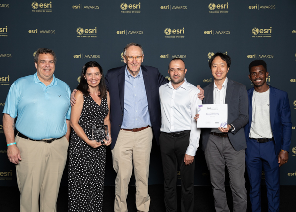
Clemson’s Center for Geospatial Technologies team pictured with Esri president and founder, Jack Dangermond, at the Esri User Conference in San Diego, California on July 10, 2023. Right to left: Patrick Claflin, Patricia Carbajales-Dale, Jack Dangermond, Maziar Fooladi, Gamumin Kato, Isaac Quaye
Since 2015, Patricia Carbajales-Dale and team have navigated intriguing frontiers in geospatial research and support at Clemson University. In fact, in less than a decade, Clemson’s Center for Geospatial Technologies (CCGT) won an Esri SAG Award for Special Achievement in Geographic Information Systems (GIS) at this year’s national convention in San Diego, California.
Esri is the global market leader in GIS software, location intelligence, and mapping. The SAG Award demonstrates an appreciation for member organizations around the world using GIS technology to understand vast amounts of data and solve complex problems.
At Clemson, Patricia and her team use Esri’s GIS technology in conjunction with Research Computing and Data’s (RCD) high-performance computing to help faculty, students, and community partners map important research data such as health disparities across the state of South Carolina, statewide large scale solar radiation analysis, or student research in traffic flow data sets so large they would ordinarily crash GIS technology on its own. Simply put, Carbajales-Dale and the CCGT team use GIS technologies to enhance student experiences, drive and expand research at Clemson, and help to improve the health of South Carolinians, and beyond.
The Esri SAG Award is annually given to 200 members out of 100,000 globally, and paired with other achievements in Esri’s Innovation Program, situates Clemson University as a national leader in geospatial technologies. According to Esri, nominations for SAG awards occurred among regional leaders in the organization who were tasked with submitting “outstanding users” for consideration. For Carbajales-Dale, this was a completely unexpected surprise and of course, something her entire team was overjoyed to learn about.
“We had no idea we were nominated,” she said. “It is a true honor. We don’t have a research agenda; we are catalysts. Our mission is to support students, faculty and local South Carolina communities, offering the latest trends and innovation. We enjoy what we do, we love the services we provide. It is so exciting to see how these efforts are gaining national recognition and attention.”
In addition to this year’s SAG award, Clemson has maintained its selection as one of seventeen universities chosen as members of Esri’s Innovation Program. Carbajales-Dale explained how this also positions Clemson to directly support other universities like Yale. She served on a panel earlier this year with members from their GIS team, and she says Clemson’s CGT is one of the youngest to ever receive and maintain this elite Esri GIS university status. For Dr. Jill Gemmill, associate vice president of RCD, these successes are the results of unique cyberinfrastructure positioning and extremely hard work.
“The CCGT team at Clemson is extremely hands-on with students and gets students deeply involved in geospatial projects,” Gemmill said. “They capitalize on our high-performance computing techniques and skills for large– scale maps and imagery. They partner with our faculty and graduate students on research grants from the National Science Foundation and leading health organizations. They are a service to the entire state and help improve lives of South Carolinians through the unique data opportunities for health impacts and disparities.”
In light of these national awards and recognition, Carbajales-Dale says she and her team plan to continue this upward trajectory. She also highlighted her gratitude for the support she and her team receive through research partnerships and investments in technology, physical space, and the people who make it all possible.
“At Clemson, thanks to investment in RCD and Geospatial technologies and partnerships with the Clemson Libraries, we are able to unite infrastructure and people, and we are gaining national recognition for this model and our efforts,” Carbajales-Dale explained. “Not every university that is a member organization of Esri has the same support. Our achievements wouldn’t be possible without those investments and because of them, we are uniquely positioned to be a leader for other universities, and we can continue to help as they try to model after us.”
To learn more about Clemson’s Geospatial Technologies Center, you can visit their website: Clemson Center for Geospatial Technologies (clemsongis.org). Clemson’s faculty, student body, and even community members are encouraged to learn more and get involved. To explore more about Esri and the SAG Awards, visit their website: Special Achievement in GIS Award | Esri User Conference.
Notices
Changes To Clemson Email Quarantine
FCC/FEMA Emergency Alert System Test on October 4, 2023
Check the status of university systems on Status Hub
Security upgrades to impact email spam retrieval beginning July 12, 2023
Campus network and TikTok — July 10, 2023
Kronos to require log-in through Duo mobile application on July 21, 2023
PeopleSoft and Banner Outage on June 11, 2023
Upcoming changes to Google Workspace
Temporary restrictions to iROAR access – Nov. 30, 2022
Welcome Back: Important IT Updates for Faculty and Staff
Welcome Back: Important IT Updates for Students
Eduroam Update – July 15, 2022
New Student Laptop Models Available for 2023-2024